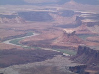
We decided to camp the night at either Bullfrog Bay North or Bullfrog Bay South, but those two campground were closed. Therefore, we continued up Notom-Bullfrog Road and camped at the Bullfrog Creek Overlook. We were the only ones there and had a great view of the Waterpocket Fold, the Henry Mountains, and, of course, Bullfrog Creek.
The next day, we back tracked on SR-276 to its junction with SR-95, then continued south on SR-95. We ended up at Kampark in Blanding where we spent a couple of days so that we could catch up on laundry and grocery shopping. Earl also washed the truck while we were in Blanding.
On Thursday, we left Blanding and drove to the Dalton Spring Campground in the Manti-La Sal National Forest west of Monticello -- $4 per day with our Golden Age Passport. No hookups, but water is available. There were deer which were around, and came very close to the RV. In fact, Maxx and one deer came almost nose to nose!


The next day, we drove to Canyonlands National Park, stopping at Newspaper Rock State Historical Monument on our way. Newspaper Rock has over 300 petroglyphs made by peoples of several different tribes including Anasazi, Fremont, Paiute, and Ute.


Canyonlands consists of 527 miles of wilderness in the Colorado Plateau. The Green and Colorado Rivers have carved flat layers of sedimentary rock into hundreds of canyons, mesas, buttes, fins, arches, and spires. The park is divided into 3 distinct districts: Island in the Sky, The Maze, and The Needles (there is a smaller Horseshoe Canyon Unit which is disconnected from the Park and to its west). The Maze District is west of the Colorado and Green Rivers and is ranked as one of the most remote and inaccessible sections in the U.S. It takes a 4-wheel drive vehicle to visit most parts of this district, so we did not visit this part of the park.
The Needles District is located east of the Colorado River, and consists of a landscape of rock spires, arches, canyons, grabens, and potholes. The dominant land form are The Needles themselves -- rock pinnacles banded in red and white. Like Arches National Park, The Needles District has a large collection of natural rock spans, many of which can be seen only if you take some of the 4-wheel drive roads. We, of course, stayed on the main, paved road through the park. We were, however, able to see the Wooden Shoe Arch (pictured below).
On Saturday, we drove into Monticello so that Earl could go golfing at the Hideout Golf Club. I went along, taking my computer, so that I could get online and do some surfing while Earl was golfing (didn't have a signal on our cell phone up at the campground).
The Needles District:


We left Monticello on Sunday, June 22, and drove to Goose Island, a BLM campground east of Moab on SR-128 ($5 per day with the Golden Age Passport. No hookups, but drinking water is available about a mile from the campground). We backed into a spot overlooking the Colorado River. On the far side of the river were tall cliffs that are part of Arches National Park -- which was nice, because it was hot while we were in Moab (90s - 100s), but we were in the shade of the cliffs by 5 or 5:30 each day, which cooled things off quite a bit. We did run our generator during the afternoon, however, so that we could turn on the A/C for awhile.
Before arriving at the campground, we stopped to view Wilson Arch and Lopez Arch. Lopez Arch isn't actually an arch (yet); rather, it's what's referred to as a "window." We also stopped at Hole 'n the Rock House, a house carved out of the cliffs.
Wilson Arch:

Lopez Arch:

Hole 'n the Rock House:

That evening, we went out to dinner at La Hacienda Mexican Restaurant.
While we were in Moab, we did laundry and grocery shopping, bought a GPS unit, had breakfast at Breakfast at Tiffiny's, lunch at Poplar Place, and Earl went golfing at Moab Golf Club.
We also ended up with a mouse in our fifth wheel -- the first one we've ever had! We figured it must have come up the electrical cord we had attached to the generator (the cord curls up in a box under the kitchen sink). The first thing we noticed was that the dog food bag, which we kept under the sink had a small hole in the bottom. The first day, I didn't really think anything about it. The next day, the hole was bigger, and there were small pieces of the bag on the floor. Earl bought a mouse trap which we at first baited with cheese. The mouse was able to eat the cheese without tripping the trap, so I jammed a piece of dry dog food into it (since the mouse apparently liked the dog food). The next morning, we had the mouse!
We also took a trip to the Island in the Sky District of Canyonlands National Park. Island in the Sky is a broad, level mesa which lies between the Colorado and the Green Rivers. Closest to the mesa's edge is the White Rim, a nearly continuous sandstone bench 1,200 feet below the Island. Another 1,000 feet beneath the White Rim are the rivers. The views were magnificent, but pictures don't do it justice.
Island in the Sky District:


No comments:
Post a Comment