
On the 1st, we took the fifth wheel and drove over to Phoenix to stay at Cotton Lane RV park for four nights so that we could do Christmas shopping and visit friends.
While in Phoenix, Earl golfed at Falcon Golf Club with friends, and we had dinner at one of his golfing buddy's homes, Rich and Ann, together with Buck and Phyllis.
Mom drove over to Quartzsite and spent the night one night before Christmas. We had a nice visit, and the next day, we had lunch at the Cactus Cafe, and then drove out to see the 47-armed Saguaro. Boy, was that a disappointment! The thing was dead -- or, if not completely dead, it sure was close to it!
We had new gravel delivered for our yard -- red rock, and we also bought some 12" square red stepping stones put down from the back steps to the shed.
Kirk and Gen Griffith came to visit for a couple of days after Christmas. We took them out to dinner at Taco Mio, and the next day we drove them around Quartzsite showing them the sites (such as they are!), stopping to have pizza at Silly Al's (MUCH better pizza that the local Pizza Hut!). We had a really nice visit with them, and they said that they might rearrange their time in Mexico next year, so that they could be here in January when all the big shows are on.
Wednesday, December 31, 2003
Sunday, November 30, 2003
NOVEMBER 2003
One of the first things we did once we arrived home, was to take a trip over to Blythe (California), and order a washer and dryer (front loader with a gas dryer). About a week later, the washer and dryer were delivered, and two young men assembled the pedestals on which both sit, and installed them (the pedestals bring the washer and dryer up higher, so that we don't have to stoop down so far to get into the machines.
We bought a tripod so that we could put up the dish that we'd received when we bought the new satellite receivers earlier in the year. Then we found out that one of the receivers was bad, so Dish Network sent us a new one. As it turned out, the second one we'd purchased earlier in the year also went bad, so in the space of a month, we had two brand new receivers! The other portable satellite dish that we had with us in the RV, was set up so that I could watch TV from my office in the fifth wheel.
We took a couple of trips over to Phoenix where we ordered a shed from Lowes which was delivered and built in one day by a single person! Once it was assembled, Earl painted the outside to match the house, and we put up insulation and wall board inside. On one of our trips to Phoenix, we also stopped by our storage room at Cotton Lane RV Park to pick up boxes of things we wanted to take back. We also had lunch with Mom on both of our trips: at On The Border the first trip, and at P.F. Chang's on the second (this second lunch as an early birthday lunch for my Mom).
On Thanksgiving, Patti Hellman came over for dinner. Don was still in Montana, so he was not able to join us.
During the month, we ate a few times at our favorite Mexican food restaurant, Taco Mio, and at Best Chinese. One night, we were feeling lazy, and ordered pizza to be delivered from the local Pizza Hut -- never again! Usually, we like Pizza Hut pizza, but the place here in Quartzsite makes terrible pizzas...mainly because they don't actually make them, they're "premade!" On a couple of Wednesdays, we also had breakfast at the Stagecoach Restaurant with other Escapees.
Friday, October 31, 2003
OCTOBER 2003
On Wednesday, October 1, we left the Joy-O RV Park in Denmark, Tennessee, and drove a little over 200 miles to the Holland Bottoms Wildlife Management Area near Jacksonville, Arkansas (free), stopping along the way to fuel up with diesel.
The next day, we drove 177 miles to stay overnight at the Clear Springs Campground on Wright Patman Lake, a Corps of Engineers campground near Texarkana, Texas ($8 per night with the Golden Age Passport). We stopped at the Cookery (Flying J) to have lunch, and did grocery shopping before arriving at the campground.
Friday night saw us at the Elks Club in Tyler, Texas. We stopped at a Cracker Barrel for lunch.
On Saturday, October 4, we arrived at our home Coast to Coast park in Whitney, Texas, Suncountry RV Resort (which has now been renamed Lake Whitney Resort & Golf), where we spent nine nights.
While in Whitney, we did laundry and grocery shopping, and ate dinner a couple of nights at Tres Hermanos, a very good Mexican food restaurant in town. We also took a couple of trips into Waco to shop at Sam's Club and PetsMart, and went by the Verizon store to get my phone fixed. They ended up giving me a new phone of the same type; however, that one quickly stopped working, too, so, since my two-year contract was just about up, I ordered a brand new phone from Verizon. Earl golfed at Lake Whitney Golf Club (the course that is part of our home park) a couple of times.
We left Whitney on Monday, October 13, and drove 140 miles to Camp Bowie Memorial City Park in Brownwood, Texas (free). This was a difficult place to find, mainly because the directions in Don Wright's Guide to Free Campgrounds were wrong.
The next day, we drove 114 miles to Twin Buttes City Park in San Angelo, Texas (another free park). We stopped in Brownwood, Texas, to fill up with diesel.
On Wednesday, we spent the night at Parkview RV Park in Fort Stockton, Texas. This was one of our Good Neighbor parks (associated with Coast to Coast), and costs $11 per night. We had dinner that night at the Steakhouse Restaurant.
The next day, we drove 121 miles to the El Campo RV Park in Van Horn, Texas. We stay at this RV park every time we stop for the night in Van Horn. The woman always recognizes us, even though the last time we were here was in 2001, when we were on our way to Alaska -- she even remembered we were going to Alaska the last time she saw us! We had lunch at Papa's Pantry, and picked up our mail.
On Friday, we had breakfast across the street from the RV park at LaCasita, and then got diesel at Love's. We drove 66 miles to Guadalupe Mountains National Park. The "campground" for RV's is nothing more than a paved parking lot, but it's convenient to the sites in the park. We walked down to the Visitor's Center in the evening to hear the Ranger talk about McKittrick Canyon, one of the popular hikes in the park. The following evening, another Ranger talked about lizards and snakes, particularly those found in the park.
View from our rig of the Guadalupe Mountains:

We left Guadalupe Mountains National Park on Sunday, October 19, and drove 209 miles to the Dreamcatcher RV Park (one of our Escapees parks) in Deming, New Mexico, where we spent eight nights. Along the way, we stopped in Anthony, Texas to have lunch at the Cookery, and then had dinner at the LaFonda in Deming. While in Deming, we did laundry and grocery shopping, and Earl golfed a couple of times at the Rio Mimbres golf course. We also took a trip down to Palomas, Mexico, where we had lunch at The Pink Store.
On Monday, October 27, we left Deming and drove 140 miles to the Elks Club in Willcox, Arizona. The lodge had just finished putting in about 20 more RV sites -- all pull throughs with water and electric. We went inside to have drinks in the evening.
The next day, we drove 105 miles to the Gilbert Ray Campground in Tucson Mountain Park near Tucson, Arizona. The last time we were at this park (when we still had our truck camper), this park cost about $12 per night. However, the price is now $20 per night. It's a beautiful park, but with only electrical hookups, at $20 per night, we probably won't stay here again.
On Wednesday, when we left the Gilbert Ray Campground, we stopped at the Cracker Barrel for breakfast, and then Costco to do shopping. We then continued on to the Jim Korsten West Pinal County Park west of Casa Grande, Arizona, off I-8 (free). We spent two nights at this park, going into Casa Grande on Thursday to do grocery shopping and laundry.
On the last day of the month, we reached HOME! After unpacking the fifth wheel (well, at least partially), we had dinner out at the Palo Verde Cafe.
Tuesday, September 30, 2003
SEPTEMBER 2003
Yup, he's at it again -- he's a professional!

We left North Vernon on Wednesday, September 3, and drove to Liberty, Indiana, where we stayed at another Coast to Coast park, Heritage Hills. The next day, Earl went golfing at the Bruce H. Gregory Golf Course.
On Friday, we drove to Auburn where we stayed at the Elks Club. The Elks RV Guide said that this lodge had 20 sites with electric and water. WRONG! There is a water bib at the southwest corner of the building, but the bartender couldn't find the handle for it, so we had to use a pair of pliers to turn it on! For electricity, an extension cord had to be put through a window of the garage to which we backed up. Not only that, but the map in the guide had the lodge located in the wrong place. Oh well, we did finally find it!
The next day, we visited the Auburn, Cord, Duesenberg Museum. The Museum is located in the building where these beautiful automobiles were made. In addition to these 3 models, the museum also had automobiles from other manufacturers, many of which were produced in Indiana! It seems that the Depression did in many of these manufacturers. We highly recommend a visit to this museum to anyone in the area.
Monday, September 8, we left Auburn and drove to the Coast to Coast park, Grand View Bend, in Howe, Indiana. While there, we took a trip to Shipshewana, an Amish village. We were going to have lunch there at a popular restaurant, but there was a very long line, so we bought some BIG cookies instead!
On Saturday, we moved to the Elkhart Campground in Elkhart. We had lunch at Bennigans, and then, in the evening, we went to dinner at the Texas Roadhouse with other fellow Boomers, including Bill and Gisela Pollock, and Ron and Donna Monroe.
Sunday morning, we formed a caravan with other Boomers who were going to park at the Escapade in the generator area, for the trip down to the fairgrounds in Goshen. People who were driving motorhomes pulling toads were required to disconnect the toad before arriving at the fairgrounds, so I drove Chris Christiansen's car since she is a solo. We got parked in short order, and walked down to the registration center to pick up our packages with all the information in them for the scheduling of classes and entertainment. We had lunch at the fairgrounds after picking up our registration packets.
The next four days were spent going to classes, visiting with friends, checking out the various vendors, and eating! We made a trip to the Das Dutchman Essenhaus Restaurant, where we'd eaten the last time we'd attended the Fall Escapade in Goshen. This restaurant has GREAT food! On the last night of the Escapade, we had a Boomer Pizza Party.
On Friday, we went back to the Grand View Bend RV park in Howe. We did grocery shopping, laundry, and, of course, dumped our tanks.
Sunday, we drove to the American Campground in Kalamazoo, Michigan, one of our Coast to Coast parks. We spent six nights at this campground, where it rained almost every day! And, of course, it was our luck to have chosen a spot where, when it rained, it became a lake!
While we were in Kalamazoo, we had dinner a couple of times at Fricanos of Alamo, a place with very good Italian food. We went back the second time because we'd seen people eating pizza which looked very good -- very thin crusts, which we like. And it was good! We also took our Yamaha generator in for repair -- it had stopped working while we were at the Escapade. Since the generator was still under warranty, the repairs were done without charge to us...the place where the repairs were done didn't even charge us for the oil change!
We originally were planning on heading north from Kalamazoo, going through the UP of Michigan, Wisconsin, Minnesota, North and South Dakota, with a stop in Sioux Falls so we could register to vote, before heading south toward Quartzsite. However, the weather reports said that this areas was going to be cold -- high's in the 40's -- so we decided to head south instead. So, on Saturday, September 27, we left Kalamazoo, headed south, and spent the night at the Driftwood Camp RV Park in Edinburgh, Indiana. We had dinner that night at the Cracker Barrel.
On Monday, we headed for Mammoth Cave National Park. We were planning on staying at a Coast to Coast park near there, but they said they were full -- which I didn't believe, but the campground at the National Park was nice. We didn't take the time to explore the Cave, so we'll have to come back and do that another time.
Tuesday saw us at the Joy-O RV Park near Denmark, Tennessee. We'd stopped and had lunch at Subway, and to fuel the truck.
Sunday, August 31, 2003
AUGUST 2003
Maxx, doing what he does best!

We spent 5 nights at the Colorado Heights Campground in Monument, Colorado. While there, we took a trip up to Denver to do shopping at Costco and Camping World.
On Tuesday, August 5, we left Monument, heading south on I-25 until we got to Pueblo, where we picked up US-50 again. Heading east on US-50, we drove to La Junta (stopping to have lunch at the Tamarack Grill in Fowler), where we went south on SR-109, and west on David Canyon Road. Our destination was Vogel Canyon in the Comanche National Grasslands. We found a nice little picnic area (free) where we set up camp for the night (N37 46.198, W 103 30.775). Good thing we had our generator, since it was hot...not like the cool weather we'd gotten used to in the higher elevations of Colorado! Fortunately, the nights cooled off, so it was comfortable sleeping without leaving the generator running. This was a really nice place to camp...nice and quiet...so we stayed here a couple of days. There was about a half-mile trail to an overlook of Vogel Canyon which we walked during the cool of the morning.
Thursday morning, we continued our trip east on US-50, stopping for lunch in Holly, Colorado, and groceries in Syracuse, Kansas. We spent the night at Beymer Kearny County Park in Lakin, Kansas ($5 per night).
The next day, we visited the Fort Larned Historical Site at Larned, Kansas. This was quite an interesting site; unfortunately, it was not only hot here, but also humid. The wind was blowing, so it wasn't too bad outside, but was uncomfortable inside the buildings which, of course, were not air conditioned.
Fort Larned was a principal guardian of the Santa Fe Trail as well as a key post in the Indian wars from 1859 to 1869. Throughout most of the 1860's, Fort Larned also served as an agency of the Indian Bureau. In the early 1870's, as the Santa Fe Railroad pushed west from Topeka, soldiers from Fort Larned provided protection for construction workers.
We spent the night at a camping spot (free) in the Cheyenne Bottoms Wildlife Area. This area consists of 7,300 acres of shallow marshes and wetlands. Nearly half of the birds that migrate east of the Rocky Mountains stop here. Of the 415 bird species in Kansas, 320 have been observed here -- more than anywhere else in the state.
On Saturday, the 9th, we made it to Junction City where we set up at the West Rolling Hills free BLM area of Milford Lake. There is a fee area that has electrical hookups, but we usually stay in the free area which has spaces right on the lake. We drove into town after setting up, and went by the Chevy dealer to order the part we needed for the truck.
Monday, we had breakfast at Cracker Barrel and did grocery shopping at the Super Wal Mart.
Tuesday, we drove into Abilene to visit the Eisenhower Center.
The Eisenhower Center is several blocks square, and consists of Eisenhower's boyhood home where his family lived from 1898 until his mother's death in 1946, a museum, the Presidential Library, and the final resting place of the President, Mamie, and their first-born son, Doud Dwight.
The museum at the Eisenhower Center was quite interesting, covering Eisenhower's military career and his time as President. There is also a gallery of the life of Mamie Doud Eisenhower, and a Temporary Gallery where exhibits change from time to time. At the time of our visit, the Temporary Gallery had a tribute to Bob Hope. This tribute was particularly poignant since Bob Hope had died on July 27, just about 2 weeks prior to our visit.
Earl went golfing on Wednesday, and on Thursday we took the truck in to have the missing spring stop replaced as well as having an oil change and tire rotation. We then had lunch at Cracker Barrel, and did grocery shopping.
We left Junction City on Friday, and spent the night at the Elks Club in Grandview, Missouri, where we also had dinner.
The next day, we arrived in Harrisburg where Ron and Donna Monroe are parked in their new Excel fifth wheel on their daughter's property out in the country. That night we had a picnic at the local winery, which would have been even more fun if it hadn't been so hot and humid! We had a great visit with Ron and Donna, and look forward to seeing them again at the Escapees' Fall Escapade in Goshen, Indiana.
We spent Monday night at the Elks Club in O'Fallon, Missouri. After setting up, we did laundry and grocery shopping.
On Tuesday, we arrived at Hickory Shores Resort near Carlyle, Illinois, one of our Coast to Coast parks. We spent a week here: Earl golfed a couple of times, we did laundry and grocery shopping, picked up our mail, and on our last night, had dinner out at the Circle B Steakhouse.
We left Hickory Shores Resort on Tuesday, and spent the night at Red Hills State Park near Lawrenceville, Illinois.
The next day, our plan was to stay at one of the numerous Forest Service campgrounds around Bedford, Indiana. After trying to find some based on the directions in the book we were using, and having no luck, we happened upon the Forest Service office, so stopped to get directions. As it turned out, everything was full due to the up coming Labor Day weekend! We ended up at Spring Mill State Park near Mitchell. This is a very nice state park, but on the expensive side -- over $20 per night! However, we decided to spend a couple of nights, and the next day, we shopped at the local Sam's Club, and picked up more dog food at PetsMart.
On Friday, August 29, we drove to North Vernon, Indiana, where we stayed at another of our Coast to Coast parks for 5 nights, Country Squire Lakes. While here, we kicked back and relaxed, doing laundry and grocery shopping.
Thursday, July 31, 2003
JULY 2003
We left Moab on Saturday, June 28 and drove to the Rangely Camper Park in Rangely, Colorado ($8 per night for no hookups, water and a dump are available -- electrical hookups for additional fee). After setting up, we went out to dinner at Los Tres Patrillas where we had some excellent Mexican food. Earl had the tamales, some of the best tamales we've ever had in a restaurant -- just like homemade!
The next day we drove to Dinosaur National Monument and stayed at the Green River Campground ($6 per night with the Golden Age Passport, no hookups). On Monday, we took the 22-mile round trip Scenic Drive through the western part of the park.
Earl Douglass discovered the dinosaur quarry when he was looking for fossils for the Carnegie Museum in 1909. The Monument was created in 1915, and consisted of 80 acres -- today it includes 210,844 acres. The park contains 23 exposed geological strata, the National Park System's most complete such record.
At the end of the road, we found Josie's Cabin -- a log cabin built by Josie Bassett on land she homesteaded from around 1914 until her death in 1964. Can't imagine homesteading all by myself!
Tour of the Tilted Rocks -- Dinosaur National Monument


On Tuesday, we returned to the Rangely Camper Park. The next day, we drove the 31-mile Harpers Corner Scenic Drive. There were thousands of Mormon Crickets on the road...crunch, crunch, crunch as we drove! Mormon Crickets are very large -- bigger than most grasshoppers (pictured below) and quite ugly! We had to watch where we stepped when we got out of the truck to see something.
If you are interested in geology, archaeology, and/or paleontology, be sure to stop and explore this park as well as the national parks and monuments in Utah. You'll receive quite an education, as well as seeing some magnificent scenery.
Harpers Corner Scenic Drive -- Dinosaur National Monument


On Thursday, July 3, when we were getting ready to leave Rangley, a hot air balloon took off from the park where we were staying.

We drove to Grand Junction where we checked in at the Junction West RV Park, and then did shopping at Sam's Club after setting up. We spent a week in Grand Junction: got more shopping done, did laundry, had lunch at the Olive Garden, and took my computer in to have it repaired. It was nice to just be able to kick back and relax for a little while after pretty much being on the go since we left Quartzsite back on May 1.
On Thursday, July 10, we left Grand Junction and drove to one of our RPI parks in Montrose, Country Village RV Park. We had lunch at Fiesta Guadalajara, and Earl golfed at The Links at Cobble.
On Saturday, we drove US-550 from Montrose to Silverton, driving over Red Mountain Pass. The section of the highway from Ouray to Silverton was exciting! Actually, just the few miles south of Ouray was a little tense -- you're on the outside with little or no shoulders, and a long drop. After that, the road isn't bad, although there are some tight turns. No problems with our small, 25' fifth wheel, though! Just south of Ouray, we stopped at Box Canyon Falls. The waterfall appears to emerge from the center of solid rock; actually, Canyon Creek eroded the fault through which water rushes 285 feet into Box Canyon below.
Downtown Ouray:

Our rig:

Box Canyon Falls

Box Canyon

We found a place to dry camp along South Mineral Creek north of Silverton. One of the fifth wheels parked near us had several hummingbird feeders out, and there were dozens of hummingbirds flying around! In fact, we've seen more hummingbirds in Colorado than we've ever seen in our entire lives before!
View from our campsite at South Fork Creek:
The second day at South Mineral Creek, we drove into Silverton and explored that town. Quite an interesting place. Stopped and had lunch at Hi Noon Hamburgers. If it hadn't been for Maxx, we would probably have taken the train ride between Silverton and Durango; however, it's about a 10- to 12-hour round trip. I suppose we could have found a kennel to put Maxx in if we'd really wanted to take the trip bad enough.
On Monday, we drove into Durango. We looked at one forest service campground for a place to stay, but didn't like any of the sites, so we ended up staying at the Durango RV Park which is about 11 miles south of Durango on US-550. We spent a week in Durango with the intention of having the missing spring stop on the right rear of the pickup replaced. We went into the local Chevy dealer to order the part, but when it came in, they had ordered the wrong part! Since it wasn't a critical part, we decided to wait until we got to Junction City, Kansas to have it replaced at the dealership where we'd purchased the truck the year before.
Molas Pass with Molas Lake in the background:

In the meantime, we did laundry, grocery shopping, washed the truck, and went out to dinner for Earl's birthday, which was on the 19th. We also took a trip into Farmington, New Mexico to do shopping at Sam's Club (Farmington is only about 50 miles south of Durango -- less from where we were staying at the RV park). While we were at Sam's Club, we purchased an Averatec laptop computer, which we'd seen at an Office Depot in Durango for about $200 more! While we were in Durango, Earl went golfing at the Dalton Ranch Golf Club.
On Monday, we headed east on US-160, stopping in Pagosa Springs for lunch at Shanhai, a Chinese restaurant, and to do grocery shopping. We continued northeast on US-160, and spent the night at Wolf Creek, a forest service campground just before Wolf Creek Pass (10,850 ft.).
The next day, we continued on to Creede where we stayed at another forest service campground, Marshall Park, which is located on the Rio Grande River.
The headwaters of the Rio Grande are to the west of Creede, in the San Juan Mountains...it starts on the slopes of the 13,821-foot Rio Grande Pyramid. The Rio Grande is the second longest river in the U.S., flowing 1,885 miles from its headwaters to the Gulf of Mexico.
Headwaters of the Rio Grande River
(note peak of Rio Grande Pyramid in background):

Creede is where my Grandmother was born, but her family only lived there until she was 6 months old, when they then moved to Idaho. We went by the local historical society, to try to find some information about her family, but had no luck. However, we did tour Creede, including the Creede Historical Museum, which is housed in the old Denver and Rio Grande Railroad Depot. We stopped to have lunch at the Tommyknocker Tavern.
Creede:

One of the mines near Creede:

Downtown Creede:

The people who were camp hosting had a couple of hummingbird feeders out, and, again, we were able to watch dozens of hummingbirds feeding -- in this case, Rufus Hummingbirds.
On Thursday, we continued west and north on SR-149, stopping at Slumgullion Pass to view the Slumgullion Earth Flow. This is an area where unstable volcanic under rock began to flow into the nearby valley 700 years ago. The mass eventually blocked the Gunnison River tributary to form Lake San Cristobal. The earth flow is still moving at the rate of about 20 feet per year!
Slumgullion Earth Flow:

When we got to Gateview, we headed north on 25 Road to Red Bridge Campground in the Curecanti National Recreational Area.
The next morning, we decided to continue north on 25 Road (also called the Blue Mesa Road) to US-50. The road started out fairly good, but degenerated into a pretty rough road. It took us quite a while to make the few miles up to US-50 since we had to go so slow. Once we made US-50, we headed east and stopped at the Elk Creek Campground, also in the Curecanti National Recreational Area. This particular campground is on the Gunnison River. After setting up, we drove into Gunnison to do grocery shopping and pick up our mail.
Sunset:

The next day, we explored the Black Canyon of the Gunnison National Park.
This canyon is called "black" because it is so deep, so sheer, and so narrow that very little sunlight can penetrate it. Only the rims show evidence of human occupation, never the gorge -- not even by the Ute Indians who lived in the area since written history began.
In just 48 miles through the canyon, the Gunnison River loses more elevation than the 1,500-mile Mississippi River does in its entire length, dropping an average of 96 feet per mile in the national park. It drops 480 feet in just one 2-mile stretch. Before the dams were built upstream, the river used to slam through the gorge during flood stage at 12,000 cubic feet per second with 2.75-million-horsepower force, scouring the riverbed and eroding the canyon walls.
We drove the South Rim Road, stopping at the various viewpoints, and had lunch at the turn around point, High Point.
Black Canyon of the Gunnison National Park


On Sunday, we drove back into Gunnison to do laundry, grocery shopping, and filled the truck up with diesel and washed it.
On our way out of town on Monday, July 28, we stopped to get our RV washed. We traveled US-50 east, stopping at Monarch Pass to have lunch. After lunch, we continued east on US-50 until we got to US-285, north of Poncha Springs, where we headed north. Turning west on 162 Road, we tried getting into Forest Service campgrounds, Mt. Princeton and Chalk Lake, but they were both full. Third time's a charm, and we were able to get into Cascade campground. We found out later that there was a whole group of people who come to this area each year to camp, and that is why the campgrounds were so full (have forgotten the details as to who they were, and what state they came from).
The next day, we continued north on US-285 until its junction with US-24, where we headed north and east on US-24 to the Round Mountain campground in the Pike National Forest. After setting up, we drove into Florissant to visit the Florissant Fossil Beds National Monument.
This is an area where, some 34 to 35 million years ago, during the late Eocene Epoch (about 30 million years after the dinosaurs and 33 million years before humans appeared), Lake Florissant existed, stretching 12 miles through an ancient forested valley. The lake was created from volcanic mudflows which created a dam across the valley. Fossils of a diverse mix of more than 140 species of plants and 1,400 species of insects have been discovered at Florissant. There are also large petrified stumps of ancient Sequoia trees.
Petrified Sequoia:

Also in the national monument, was the Hornbek Homestead. Adeline Hornbek was the first to homestead land in what is now the Florissant Fossil Beds National Monument. She was the sole support of her family, which consisted of four children, and got the land under the Homestead Act of 1862. Under this act, Congress offered free public land to settlers. The homesteader was required to be a loyal U.S. citizen (or declare intent to become a citizen), head of a family, and over 21 years of age. Five years of continuous residence on, and improvement of, the land was necessary before the final proof could be made. For the first time in American history, women had access to land ownership, since the Act specified that not a man, but a head of the family could file. Makes one wonder if that language was an error on the Congress' part, especially considering women couldn't even vote at the time...they may never have considered the fact that a "head of household" could be a woman! At any rate, Adeline Hornbek built up quite a successful homestead.
Adeline Hornbek Homestead:

On Wednesday, we drove into Cripple Creek, found a place to park, and walked around town. Cripple Creek is the site of the largest gold-producing deposit on earth. We could see that the town had been a prosperous mining town, as most of the building downtown were brick rather than wood that one sees in most of the old mining towns. However, we were disappointed to see that almost all the buildings were now turned over to gambling.
Downtown Cripple Creek:

Thursday morning, we left Round Mountain and drove into Monument (north of Colorado Springs) where we stayed at one of our Coast to Coast parks, Colorado Heights. When setting up our satellite dish, we discovered that our receiver didn't work. I called Dish Network's technical support, but we never could get the receiver to work. So Earl and I drove into Colorado Springs and bought a new receiver at Comp USA (actually, it was a complete system with 2 receivers and a dish). Then, of course, I had to go through the whole procedure of setting up the new receiver, and calling Dish Network back to get it up and running. After all that, we decided to go out to eat, so we had dinner at On The Border.
The next day we drove to Dinosaur National Monument and stayed at the Green River Campground ($6 per night with the Golden Age Passport, no hookups). On Monday, we took the 22-mile round trip Scenic Drive through the western part of the park.
Earl Douglass discovered the dinosaur quarry when he was looking for fossils for the Carnegie Museum in 1909. The Monument was created in 1915, and consisted of 80 acres -- today it includes 210,844 acres. The park contains 23 exposed geological strata, the National Park System's most complete such record.
At the end of the road, we found Josie's Cabin -- a log cabin built by Josie Bassett on land she homesteaded from around 1914 until her death in 1964. Can't imagine homesteading all by myself!
Tour of the Tilted Rocks -- Dinosaur National Monument


On Tuesday, we returned to the Rangely Camper Park. The next day, we drove the 31-mile Harpers Corner Scenic Drive. There were thousands of Mormon Crickets on the road...crunch, crunch, crunch as we drove! Mormon Crickets are very large -- bigger than most grasshoppers (pictured below) and quite ugly! We had to watch where we stepped when we got out of the truck to see something.
If you are interested in geology, archaeology, and/or paleontology, be sure to stop and explore this park as well as the national parks and monuments in Utah. You'll receive quite an education, as well as seeing some magnificent scenery.
Harpers Corner Scenic Drive -- Dinosaur National Monument


On Thursday, July 3, when we were getting ready to leave Rangley, a hot air balloon took off from the park where we were staying.

We drove to Grand Junction where we checked in at the Junction West RV Park, and then did shopping at Sam's Club after setting up. We spent a week in Grand Junction: got more shopping done, did laundry, had lunch at the Olive Garden, and took my computer in to have it repaired. It was nice to just be able to kick back and relax for a little while after pretty much being on the go since we left Quartzsite back on May 1.
On Thursday, July 10, we left Grand Junction and drove to one of our RPI parks in Montrose, Country Village RV Park. We had lunch at Fiesta Guadalajara, and Earl golfed at The Links at Cobble.
On Saturday, we drove US-550 from Montrose to Silverton, driving over Red Mountain Pass. The section of the highway from Ouray to Silverton was exciting! Actually, just the few miles south of Ouray was a little tense -- you're on the outside with little or no shoulders, and a long drop. After that, the road isn't bad, although there are some tight turns. No problems with our small, 25' fifth wheel, though! Just south of Ouray, we stopped at Box Canyon Falls. The waterfall appears to emerge from the center of solid rock; actually, Canyon Creek eroded the fault through which water rushes 285 feet into Box Canyon below.
Downtown Ouray:

Our rig:

Box Canyon Falls

Box Canyon

We found a place to dry camp along South Mineral Creek north of Silverton. One of the fifth wheels parked near us had several hummingbird feeders out, and there were dozens of hummingbirds flying around! In fact, we've seen more hummingbirds in Colorado than we've ever seen in our entire lives before!
View from our campsite at South Fork Creek:

The second day at South Mineral Creek, we drove into Silverton and explored that town. Quite an interesting place. Stopped and had lunch at Hi Noon Hamburgers. If it hadn't been for Maxx, we would probably have taken the train ride between Silverton and Durango; however, it's about a 10- to 12-hour round trip. I suppose we could have found a kennel to put Maxx in if we'd really wanted to take the trip bad enough.
On Monday, we drove into Durango. We looked at one forest service campground for a place to stay, but didn't like any of the sites, so we ended up staying at the Durango RV Park which is about 11 miles south of Durango on US-550. We spent a week in Durango with the intention of having the missing spring stop on the right rear of the pickup replaced. We went into the local Chevy dealer to order the part, but when it came in, they had ordered the wrong part! Since it wasn't a critical part, we decided to wait until we got to Junction City, Kansas to have it replaced at the dealership where we'd purchased the truck the year before.
Molas Pass with Molas Lake in the background:

In the meantime, we did laundry, grocery shopping, washed the truck, and went out to dinner for Earl's birthday, which was on the 19th. We also took a trip into Farmington, New Mexico to do shopping at Sam's Club (Farmington is only about 50 miles south of Durango -- less from where we were staying at the RV park). While we were at Sam's Club, we purchased an Averatec laptop computer, which we'd seen at an Office Depot in Durango for about $200 more! While we were in Durango, Earl went golfing at the Dalton Ranch Golf Club.
On Monday, we headed east on US-160, stopping in Pagosa Springs for lunch at Shanhai, a Chinese restaurant, and to do grocery shopping. We continued northeast on US-160, and spent the night at Wolf Creek, a forest service campground just before Wolf Creek Pass (10,850 ft.).
The next day, we continued on to Creede where we stayed at another forest service campground, Marshall Park, which is located on the Rio Grande River.
The headwaters of the Rio Grande are to the west of Creede, in the San Juan Mountains...it starts on the slopes of the 13,821-foot Rio Grande Pyramid. The Rio Grande is the second longest river in the U.S., flowing 1,885 miles from its headwaters to the Gulf of Mexico.
Headwaters of the Rio Grande River
(note peak of Rio Grande Pyramid in background):

Creede is where my Grandmother was born, but her family only lived there until she was 6 months old, when they then moved to Idaho. We went by the local historical society, to try to find some information about her family, but had no luck. However, we did tour Creede, including the Creede Historical Museum, which is housed in the old Denver and Rio Grande Railroad Depot. We stopped to have lunch at the Tommyknocker Tavern.
Creede:

One of the mines near Creede:

Downtown Creede:

The people who were camp hosting had a couple of hummingbird feeders out, and, again, we were able to watch dozens of hummingbirds feeding -- in this case, Rufus Hummingbirds.
On Thursday, we continued west and north on SR-149, stopping at Slumgullion Pass to view the Slumgullion Earth Flow. This is an area where unstable volcanic under rock began to flow into the nearby valley 700 years ago. The mass eventually blocked the Gunnison River tributary to form Lake San Cristobal. The earth flow is still moving at the rate of about 20 feet per year!
Slumgullion Earth Flow:

When we got to Gateview, we headed north on 25 Road to Red Bridge Campground in the Curecanti National Recreational Area.
The next morning, we decided to continue north on 25 Road (also called the Blue Mesa Road) to US-50. The road started out fairly good, but degenerated into a pretty rough road. It took us quite a while to make the few miles up to US-50 since we had to go so slow. Once we made US-50, we headed east and stopped at the Elk Creek Campground, also in the Curecanti National Recreational Area. This particular campground is on the Gunnison River. After setting up, we drove into Gunnison to do grocery shopping and pick up our mail.
Sunset:

The next day, we explored the Black Canyon of the Gunnison National Park.
This canyon is called "black" because it is so deep, so sheer, and so narrow that very little sunlight can penetrate it. Only the rims show evidence of human occupation, never the gorge -- not even by the Ute Indians who lived in the area since written history began.
In just 48 miles through the canyon, the Gunnison River loses more elevation than the 1,500-mile Mississippi River does in its entire length, dropping an average of 96 feet per mile in the national park. It drops 480 feet in just one 2-mile stretch. Before the dams were built upstream, the river used to slam through the gorge during flood stage at 12,000 cubic feet per second with 2.75-million-horsepower force, scouring the riverbed and eroding the canyon walls.
We drove the South Rim Road, stopping at the various viewpoints, and had lunch at the turn around point, High Point.
Black Canyon of the Gunnison National Park


On Sunday, we drove back into Gunnison to do laundry, grocery shopping, and filled the truck up with diesel and washed it.
On our way out of town on Monday, July 28, we stopped to get our RV washed. We traveled US-50 east, stopping at Monarch Pass to have lunch. After lunch, we continued east on US-50 until we got to US-285, north of Poncha Springs, where we headed north. Turning west on 162 Road, we tried getting into Forest Service campgrounds, Mt. Princeton and Chalk Lake, but they were both full. Third time's a charm, and we were able to get into Cascade campground. We found out later that there was a whole group of people who come to this area each year to camp, and that is why the campgrounds were so full (have forgotten the details as to who they were, and what state they came from).
The next day, we continued north on US-285 until its junction with US-24, where we headed north and east on US-24 to the Round Mountain campground in the Pike National Forest. After setting up, we drove into Florissant to visit the Florissant Fossil Beds National Monument.
This is an area where, some 34 to 35 million years ago, during the late Eocene Epoch (about 30 million years after the dinosaurs and 33 million years before humans appeared), Lake Florissant existed, stretching 12 miles through an ancient forested valley. The lake was created from volcanic mudflows which created a dam across the valley. Fossils of a diverse mix of more than 140 species of plants and 1,400 species of insects have been discovered at Florissant. There are also large petrified stumps of ancient Sequoia trees.
Petrified Sequoia:

Also in the national monument, was the Hornbek Homestead. Adeline Hornbek was the first to homestead land in what is now the Florissant Fossil Beds National Monument. She was the sole support of her family, which consisted of four children, and got the land under the Homestead Act of 1862. Under this act, Congress offered free public land to settlers. The homesteader was required to be a loyal U.S. citizen (or declare intent to become a citizen), head of a family, and over 21 years of age. Five years of continuous residence on, and improvement of, the land was necessary before the final proof could be made. For the first time in American history, women had access to land ownership, since the Act specified that not a man, but a head of the family could file. Makes one wonder if that language was an error on the Congress' part, especially considering women couldn't even vote at the time...they may never have considered the fact that a "head of household" could be a woman! At any rate, Adeline Hornbek built up quite a successful homestead.
Adeline Hornbek Homestead:

On Wednesday, we drove into Cripple Creek, found a place to park, and walked around town. Cripple Creek is the site of the largest gold-producing deposit on earth. We could see that the town had been a prosperous mining town, as most of the building downtown were brick rather than wood that one sees in most of the old mining towns. However, we were disappointed to see that almost all the buildings were now turned over to gambling.
Downtown Cripple Creek:

Thursday morning, we left Round Mountain and drove into Monument (north of Colorado Springs) where we stayed at one of our Coast to Coast parks, Colorado Heights. When setting up our satellite dish, we discovered that our receiver didn't work. I called Dish Network's technical support, but we never could get the receiver to work. So Earl and I drove into Colorado Springs and bought a new receiver at Comp USA (actually, it was a complete system with 2 receivers and a dish). Then, of course, I had to go through the whole procedure of setting up the new receiver, and calling Dish Network back to get it up and running. After all that, we decided to go out to eat, so we had dinner at On The Border.
Saturday, June 21, 2003
CANYONLANDS NATIONAL PARK
We left Capitol Reef on Monday, June 16 and headed for Bullfrog, stopping in Hanksville on our way to do grocery shopping. Bullfrog is located on Bullfrog Bay of Lake Powell in the Glen Canyon National Recreation area. We were originally going to cross Bullfrog Bay on the ferry to continue our trip on SR-276; however, after going down to the loading docks and finding out it would cost around $35 for the trip, we decided we wouldn't go that way.
We decided to camp the night at either Bullfrog Bay North or Bullfrog Bay South, but those two campground were closed. Therefore, we continued up Notom-Bullfrog Road and camped at the Bullfrog Creek Overlook. We were the only ones there and had a great view of the Waterpocket Fold, the Henry Mountains, and, of course, Bullfrog Creek.
The next day, we back tracked on SR-276 to its junction with SR-95, then continued south on SR-95. We ended up at Kampark in Blanding where we spent a couple of days so that we could catch up on laundry and grocery shopping. Earl also washed the truck while we were in Blanding.
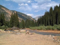
On Thursday, we left Blanding and drove to the Dalton Spring Campground in the Manti-La Sal National Forest west of Monticello -- $4 per day with our Golden Age Passport. No hookups, but water is available. There were deer which were around, and came very close to the RV. In fact, Maxx and one deer came almost nose to nose!


The next day, we drove to Canyonlands National Park, stopping at Newspaper Rock State Historical Monument on our way. Newspaper Rock has over 300 petroglyphs made by peoples of several different tribes including Anasazi, Fremont, Paiute, and Ute.


Canyonlands consists of 527 miles of wilderness in the Colorado Plateau. The Green and Colorado Rivers have carved flat layers of sedimentary rock into hundreds of canyons, mesas, buttes, fins, arches, and spires. The park is divided into 3 distinct districts: Island in the Sky, The Maze, and The Needles (there is a smaller Horseshoe Canyon Unit which is disconnected from the Park and to its west). The Maze District is west of the Colorado and Green Rivers and is ranked as one of the most remote and inaccessible sections in the U.S. It takes a 4-wheel drive vehicle to visit most parts of this district, so we did not visit this part of the park.
The Needles District is located east of the Colorado River, and consists of a landscape of rock spires, arches, canyons, grabens, and potholes. The dominant land form are The Needles themselves -- rock pinnacles banded in red and white. Like Arches National Park, The Needles District has a large collection of natural rock spans, many of which can be seen only if you take some of the 4-wheel drive roads. We, of course, stayed on the main, paved road through the park. We were, however, able to see the Wooden Shoe Arch (pictured below).
On Saturday, we drove into Monticello so that Earl could go golfing at the Hideout Golf Club. I went along, taking my computer, so that I could get online and do some surfing while Earl was golfing (didn't have a signal on our cell phone up at the campground).
The Needles District:


We left Monticello on Sunday, June 22, and drove to Goose Island, a BLM campground east of Moab on SR-128 ($5 per day with the Golden Age Passport. No hookups, but drinking water is available about a mile from the campground). We backed into a spot overlooking the Colorado River. On the far side of the river were tall cliffs that are part of Arches National Park -- which was nice, because it was hot while we were in Moab (90s - 100s), but we were in the shade of the cliffs by 5 or 5:30 each day, which cooled things off quite a bit. We did run our generator during the afternoon, however, so that we could turn on the A/C for awhile.
Before arriving at the campground, we stopped to view Wilson Arch and Lopez Arch. Lopez Arch isn't actually an arch (yet); rather, it's what's referred to as a "window." We also stopped at Hole 'n the Rock House, a house carved out of the cliffs.
Wilson Arch:

Lopez Arch:

Hole 'n the Rock House:

That evening, we went out to dinner at La Hacienda Mexican Restaurant.
While we were in Moab, we did laundry and grocery shopping, bought a GPS unit, had breakfast at Breakfast at Tiffiny's, lunch at Poplar Place, and Earl went golfing at Moab Golf Club.
We also ended up with a mouse in our fifth wheel -- the first one we've ever had! We figured it must have come up the electrical cord we had attached to the generator (the cord curls up in a box under the kitchen sink). The first thing we noticed was that the dog food bag, which we kept under the sink had a small hole in the bottom. The first day, I didn't really think anything about it. The next day, the hole was bigger, and there were small pieces of the bag on the floor. Earl bought a mouse trap which we at first baited with cheese. The mouse was able to eat the cheese without tripping the trap, so I jammed a piece of dry dog food into it (since the mouse apparently liked the dog food). The next morning, we had the mouse!
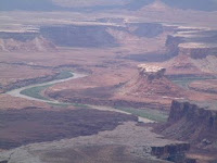
We also took a trip to the Island in the Sky District of Canyonlands National Park. Island in the Sky is a broad, level mesa which lies between the Colorado and the Green Rivers. Closest to the mesa's edge is the White Rim, a nearly continuous sandstone bench 1,200 feet below the Island. Another 1,000 feet beneath the White Rim are the rivers. The views were magnificent, but pictures don't do it justice.
Island in the Sky District:


We decided to camp the night at either Bullfrog Bay North or Bullfrog Bay South, but those two campground were closed. Therefore, we continued up Notom-Bullfrog Road and camped at the Bullfrog Creek Overlook. We were the only ones there and had a great view of the Waterpocket Fold, the Henry Mountains, and, of course, Bullfrog Creek.
The next day, we back tracked on SR-276 to its junction with SR-95, then continued south on SR-95. We ended up at Kampark in Blanding where we spent a couple of days so that we could catch up on laundry and grocery shopping. Earl also washed the truck while we were in Blanding.
On Thursday, we left Blanding and drove to the Dalton Spring Campground in the Manti-La Sal National Forest west of Monticello -- $4 per day with our Golden Age Passport. No hookups, but water is available. There were deer which were around, and came very close to the RV. In fact, Maxx and one deer came almost nose to nose!


The next day, we drove to Canyonlands National Park, stopping at Newspaper Rock State Historical Monument on our way. Newspaper Rock has over 300 petroglyphs made by peoples of several different tribes including Anasazi, Fremont, Paiute, and Ute.


Canyonlands consists of 527 miles of wilderness in the Colorado Plateau. The Green and Colorado Rivers have carved flat layers of sedimentary rock into hundreds of canyons, mesas, buttes, fins, arches, and spires. The park is divided into 3 distinct districts: Island in the Sky, The Maze, and The Needles (there is a smaller Horseshoe Canyon Unit which is disconnected from the Park and to its west). The Maze District is west of the Colorado and Green Rivers and is ranked as one of the most remote and inaccessible sections in the U.S. It takes a 4-wheel drive vehicle to visit most parts of this district, so we did not visit this part of the park.
The Needles District is located east of the Colorado River, and consists of a landscape of rock spires, arches, canyons, grabens, and potholes. The dominant land form are The Needles themselves -- rock pinnacles banded in red and white. Like Arches National Park, The Needles District has a large collection of natural rock spans, many of which can be seen only if you take some of the 4-wheel drive roads. We, of course, stayed on the main, paved road through the park. We were, however, able to see the Wooden Shoe Arch (pictured below).
On Saturday, we drove into Monticello so that Earl could go golfing at the Hideout Golf Club. I went along, taking my computer, so that I could get online and do some surfing while Earl was golfing (didn't have a signal on our cell phone up at the campground).
The Needles District:


We left Monticello on Sunday, June 22, and drove to Goose Island, a BLM campground east of Moab on SR-128 ($5 per day with the Golden Age Passport. No hookups, but drinking water is available about a mile from the campground). We backed into a spot overlooking the Colorado River. On the far side of the river were tall cliffs that are part of Arches National Park -- which was nice, because it was hot while we were in Moab (90s - 100s), but we were in the shade of the cliffs by 5 or 5:30 each day, which cooled things off quite a bit. We did run our generator during the afternoon, however, so that we could turn on the A/C for awhile.
Before arriving at the campground, we stopped to view Wilson Arch and Lopez Arch. Lopez Arch isn't actually an arch (yet); rather, it's what's referred to as a "window." We also stopped at Hole 'n the Rock House, a house carved out of the cliffs.
Wilson Arch:

Lopez Arch:

Hole 'n the Rock House:

That evening, we went out to dinner at La Hacienda Mexican Restaurant.
While we were in Moab, we did laundry and grocery shopping, bought a GPS unit, had breakfast at Breakfast at Tiffiny's, lunch at Poplar Place, and Earl went golfing at Moab Golf Club.
We also ended up with a mouse in our fifth wheel -- the first one we've ever had! We figured it must have come up the electrical cord we had attached to the generator (the cord curls up in a box under the kitchen sink). The first thing we noticed was that the dog food bag, which we kept under the sink had a small hole in the bottom. The first day, I didn't really think anything about it. The next day, the hole was bigger, and there were small pieces of the bag on the floor. Earl bought a mouse trap which we at first baited with cheese. The mouse was able to eat the cheese without tripping the trap, so I jammed a piece of dry dog food into it (since the mouse apparently liked the dog food). The next morning, we had the mouse!
We also took a trip to the Island in the Sky District of Canyonlands National Park. Island in the Sky is a broad, level mesa which lies between the Colorado and the Green Rivers. Closest to the mesa's edge is the White Rim, a nearly continuous sandstone bench 1,200 feet below the Island. Another 1,000 feet beneath the White Rim are the rivers. The views were magnificent, but pictures don't do it justice.
Island in the Sky District:


Subscribe to:
Posts (Atom)