We left Joshua Tree National Park on Saturday, the 3rd, and headed to Boron via SR-62/SR-247/SR-18/US-396/SR-58. We made the stop in Boron so that we could have a late lunch/early dinner at Domingo's, a Mexican restaurant we'd eaten at on a previous trip in March 2001. If you like Mexican food, and are ever close to Boron (west of Barstow on SR-58), stop by and eat at Domingo's -- they have excellent food! After eating, we headed for Red Rock Canyon State Park, north of Mojave on SR-14, where we spent the night ($7/night with senior citizens discount; no hookups, dump available).
Our rig at Red Rock State Park:

The next day, we stopped at the Camping World in Bakersfield to pick up a few items. This is the
smallest Camping World we've ever been to -- it was so small, it would be hard to change your mind in it! After that stop, we headed north on SR-65 and spent the night at the Elks Club in Visalia ($8/night for dry camping, dump available).
In the morning, we had breakfast at the I-Hop and then bought a DVD player at Circuit City and a 140-watt portable inverter at Radio Shack. We stopped at the Pets Mart in Fresno to pick up dog food for Maxx and then drove on to Park Sierra, the Escapees' park in Coarsegold (north of Fresno on SR-41, not too far from the south entrance to Yosemite National Park) where we got a space for a week ($90/week). This park is probably the prettiest park of all the Escapees' parks we've been to (we've been to all of them in the western half of the U.S., except for Jojoba Hills in Aguanga, California).
The reason we'd stopped at Coarsegold was to visit with friends, Gus and Judy, who own a lot at Park Sierra. But, since they both work, we wouldn't see them until the weekend, so we took it pretty easy during the week. We were going to take a day trip to Yosemite, but it rained on the day we had chosen, so didn't make it. On Friday, we did laundry, and in the evening Gus and Judy arrived and came over with a couple of pizzas.
Saturday morning we went into Coarsegold to have breakfast at a restaurant with Gus and Judy, and that evening we had dinner with them at the Crab Cakes in Oakhurst. Sunday morning, before they had to leave, Gus made his special breakfast -- homemade flour tortillas with scrambled eggs, bacon, guacamole, and salsa. We really enjoyed seeing Gus and Judy again -- the last time we'd visited with them was back in March 2001.
We left Coarsegold on Monday morning and stopped in Oakhurst to do grocery shopping. We then drove north on SR-49, stopping in Mariposa to have lunch at the Happy Burger Diner. After lunch, we continued north and spent the night at the Elks Club in Sonora (free, but we left a donation of $5; dry camping only).
The next day, we drove to Placerville where we did grocery shopping and had lunch. Then we continued on to Ghost Mountain Ranch in Pollock Pines (east of Placerville on US-50), one of our RPI parks ($5/night; water and electric, dump available). There are many interesting places along SR-49 -- old mining towns -- and we've decided that we'll drive that road again someday, taking more time to explore all the little towns.
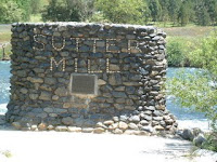
On Wednesday, we drove back to Placerville and then north to the Marshall Gold Discovery State Park in Coloma, the site of the famous gold discovery at Sutter's Mill on January 24, 1848. A full-size working replica of Sutter's Mill has been constructed in the park and downstream from this replica is a monument that marks the spot where the original mill stood. We spent most of the day walking around the town, stopping to have lunch at the Argonant Refreshment Saloon where we split a sandwich and then each had a piece of homemade pie a la mode (Earl had apple, I had peach).
Sutter Mill Monument:
Wildflowers:

On Friday, we headed east on US-50, stopping in Carson City, Nevada to do shopping at Costco and having lunch. While we had lunch in our rig, I downloaded e-mail since we were in a place where I had a good signal on the cell phone. After lunch, we drove to Dayton State Park in Dayton ($10/night; water available, dump was closed).
Bridal View Falls:

First view of Lake Tahoe:

The next day, we drove up to Virginia City and spent the day exploring that old mining town, stopping to have lunch at the Firehouse BBQ and touring the Fourth Ward School, which has been turned into a museum. Included among the other exhibits in this museum is the Mark Twain Exhibit that tells the history of Samuel Clemens who lived in Virginia City for about 20 months and worked for the Territorial Enterprise newspaper.
Fourth Ward School & Museum:

Typewriter:

(Note the separate rows on the typewriter for capital and small letters)
Main Street, Virginia City:

View leaving Virginia City:

On Sunday, we drove back to Carson City where we spent the night in the RV lot at the Nugget Casino (free; dry camping only). The reason we'd come back to Carson City was because I had a strong signal on the cell phone and could get online and do some surfing (weekends are the only time I can surf, since we have over 3,300 weekend minutes during the month, but just have 150 minutes during the week). When we arrived at the Nugget, we noticed a New Horizons parked there, too. The owner wasn't home, so I wrote a note on the back of our calling card and taped it to the door. Later, the owner, Bonnie Doone, came over and we had a nice visit. It turns out we'd met each other at one of the New Horizons rallies.
On Monday, we had breakfast at the casino and then continued east on US-50, stopping at the Churchill County Fairgrounds in Fallon where we dry camped for a couple of nights ($5/night for dry camping, $12/night for water and electric hookups, dump available). We were going to stay at the Elks Club since our Elks Travel Guide said they had RV parking here; however, the parking lot was quite small -- maybe OK for a truck camper or very small Class C, but not for our 25' fifth wheel and truck. The next day we toured the Churchill County Museum and drove out to Grimes Point-Hidden Cave Archaeological Site where we took the walking tour to look at all the petroglyphs. These petroglyphs weren't as interesting as the ones we'd seen in Petrified Forest National Park last fall -- these were mainly just wavy lines and circles, although there was one rock up by the caves that had a recognizable picture. Grimes Point is one of the oldest petroglyph sites in the Great Basin -- evidence suggests that humans have occupied this area for some 10,000 years, when this area was on the shores of the prehistoric Lake Lahontan (at its maximum, Lake Lahontan covered 8,570 square miles -- larger than Lake Ontario).
Petroglyphs at Grimes Point-Hidden Cave Archaeological Site:


We left Fallon on Wednesday and headed to the Berlin-Ichthyosaur State Park east of Gabbs on SR-844 ($11/night, including the $3 entrance fee; dry camping with water and dump available). The park sits at 7,000 feet on the western slope of the Shoshone Mountain Range and has a wonderful view west of the Ione Valley and the Paradise Range. We took a walking tour of Berlin, a mining town that was in existence from 1896 to 1911. The total production of the Berlin mine's three miles of tunnels is estimated to have been $849,000 at a time when gold was $20 per ounce.
Sand Mountain:

Dry remnant of Lake Lahontan:

(Sand Mountain, east of Fallon, is 1.6 miles long, .3 miles wide, and 370 feet high.)
Berlin:


Crushing Mill at Berlin:

We also went up to the fossil shelter, but weren't able to get inside since they don't open until Memorial Day. We were able to look in the windows and see where they've uncovered many Ichthyosaurs (ICK-thee-o-sors). A total of about 40 Ichthyosaurs have been discovered in various locations throughout the park, and of all the Ichthyosaurs discovered, the ones at this park are the largest specimens known with most being about 50 feet long. Ichthyosaurs were prehistoric marine reptiles and resembled modern day whales and dolphins (to which they are not related) in that they bore their young alive and breathed air. Living at about the same time as the dinosaurs, fossils are found on all continents except Antarctica.
Site of the Ichthyosaur dig and frieze showing
reconstruction based on remains found:


View from our campsite:

On Friday, we continued our drive east on US-50, stopping in Austin to have lunch at the Toiyabe Cafe and pick up our mail. We then drove on to Hickison Petroglyph Recreation Area, about 20-25 miles east of Austin (free; dry camping only, no water or dump). We took the self-guided walking tour once it got cooler in the evening.
Besides the petroglyphs found here, there are numerous prehistoric hunting and living sites in the area dating back as far as 10,000 BC. At that time, many of the valleys in the Great Basin supported large lakes and it appears that people were living around these lakes exploiting the abundant plants and animals dependent upon the lakes.
View of Toiyabe Range:

Rocks with petroglyphs:

The next night we spent at Illipah Reservoir Recreation Area about 30 miles east of Ely (free, no water or dump available). The campground sits up above the small reservoir with a great view of the Moorman Ridge, part of the White Pine Range. We had a thunderstorm while we were taking a nap; Maxx jumped up on the bed and got under the covers as he normally does when it thunders (to protect us, of course).
Illipah Reservoir:

On Sunday, we drove into Ely and parked at the Holiday Inn Prospector Casino (free the first night, then $9.96/night with a maximum stay of 5 days; full hookups). We had lunch at the Prospector Cafe and then did grocery shopping. The next day we did laundry and visited with a very nice couple, Bob & Jeanne Hawk, who are staying at the same park and have a New Horizons fifth wheel. On Tuesday, Earl went golfing -- the first time he's done any golfing since we left Goodyear.
Wednesday we headed to Great Basin National Park and the Lower Lehman Creek Campground ($5 per night with the Golden Age Passport; no hookups, but dump and fresh water available). This is a beautiful park in the Snake Range at the base of Wheeler Peak (13,068 feet).
We took the one-hour tour of Lehman Caves (the 90-minute tour was filled). Lehman Caves is actually one large limestone cavern that extends 1/4 mile into the mountain. Some of the nation's most highly decorated, unique formations are found within the cave -- in addition to the normal stalactites and stalagmites that one sees in most caves, there are some very rare structures known as shields. Shields consist of two roughly circular halves, almost like flattened clam shells. We were told that we couldn't take cameras into the cave, but that wasn't the case as there was a person there taking pictures, so next time, we'll take our camera!
We also drove the Wheeler Peak Scenic Drive which winds its way 12 miles to the 10,000 foot elevation on the flank of Wheeler Peak providing spectacular scenery. One can take a trail leading to the top of Wheeler Peak where one will have amazing view for hundreds of miles in all directions (we didn't take the hike!).
Wheeler Peak:

View from the scenic drive:

Great Basin National Park extends from the upper Sonoran sagebrush life zone to the Arctic Alpine tundra life zone. At our campground (at a little over 7,000 feet of elevation), we saw deer, mice, chipmunks (all of which Maxx would have loved to chase!), and we watched a Red-Naped Sapsucker make the rounds of the trees he'd carved little pieces of bark out of. Not only did he eat the sap, but the sap would attract bugs which he'd come and eat, too! We also saw a Rufous-sided Towhee and some hummingbirds which were probably either the Broad-tailed or the Black-chinned (we weren't really sure which ones we were seeing, but both of their habitats are in the area.
Deer:

Red-naped Sapsucker:

Saturday we left the park and drove to Delta, Utah, where we checked into the Antelope Valley RV Park, one of our RPI parks ($5 per night). After setting up, we drove into town and had lunch at the Pizza House then went by Delta Sports Center to buy a Yamaha EF3000iSE generator. We're going to be boondocking in some hot weather and our little 1000-watt Honda generator will not run the air conditioner, so we need something bigger. Delta Sports Center gave us what we considered to be a very generous trade-in on our Honda, so the final price of the Yamaha was less than we thought we'd have to pay.


